
Deadly floods and landslides in the southeast showed that warnings alone cannot protect communities living on unstable slopes, beside blocked drains and in fragile refugee shelters.
Record rainfall, deadly landslides and widespread flooding across southeastern Bangladesh have exposed the distance between forecasting a hazard and protecting the people most likely to be hit.
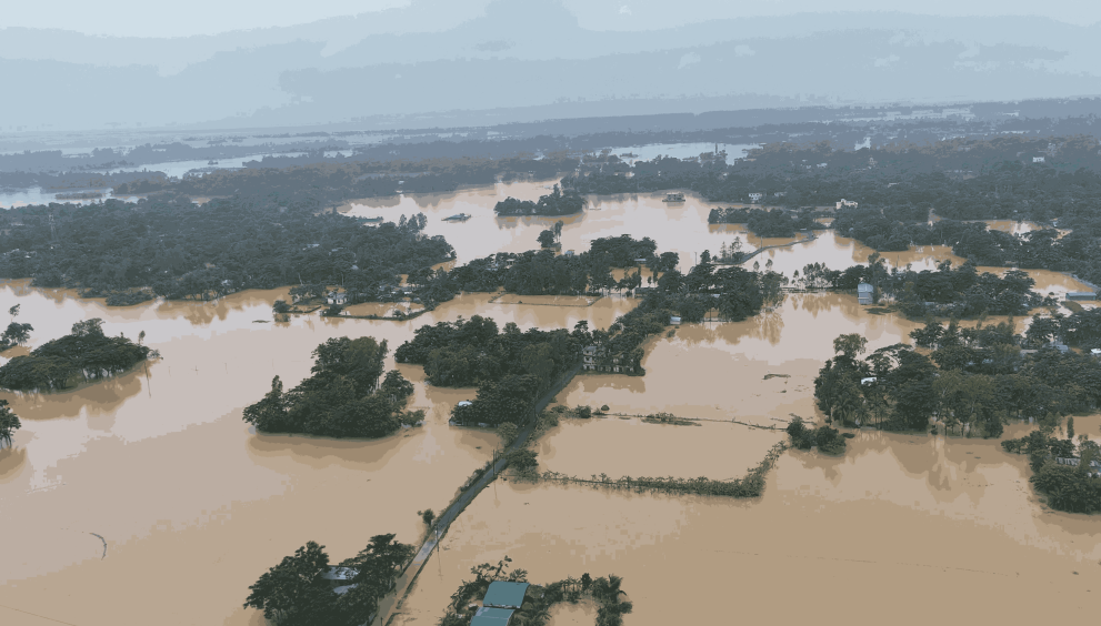
Chittagong recorded more than 412 millimetres of rain in 24 hours, the highest total in more than four decades, as intense monsoon weather flooded neighbourhoods, cut transport links and destabilised hillsides. High tide slowed the drainage of storm water, leaving parts of the port city under water even after the heaviest rain eased.
By July 11, at least 44 people had been killed and more than one million stranded across seven districts, according to government figures reported by Reuters. The authorities said 267,918 households had been marooned. The affected area included Chittagong, Cox’s Bazar, Bandarban, Rangamati, Khagrachhari, Moulvibazar and Habiganj.
The toll developed quickly and official counts changed as rescuers reached remote areas. A Chittagong district assessment released on July 13 said 754,590 people from 188,648 families had been affected across 16 subdistricts and the metropolitan area. The different figures describe assessments at different times and geographic scales rather than a single settled total.
The army and navy deployed personnel and boats to carry food, drinking water and medicine. Roads, bridges and rail services were disrupted, while flooding interfered with operations at the airport and around the country’s main seaport. In many low-lying communities, residents waited on raised roads, roofs and embankments for water to fall.
The crisis was especially acute in and around the Rohingya refugee camps in Cox’s Bazar. By July 11, landslides had killed at least 16 refugees. More than one million Rohingya live in and around the camps, many in bamboo and tarpaulin shelters built on steep, heavily altered hills where intense rainfall can turn soil into a fast-moving mass of mud and debris.
Authorities moved at least 1,000 refugees from dangerous locations after landslides struck. Emergency relocation can save lives, but it is hardest when space is scarce, shelters are crowded and residents fear losing possessions, documents or access to aid. Evacuation plans must therefore be built with communities before rain begins, not improvised at the height of a storm.
Bangladesh is accustomed to monsoon rain, but familiarity does not make the danger routine. A disaster emerges from the combination of a physical hazard and human exposure. Extreme rain becomes more destructive when slopes have been cut, trees removed, drains narrowed, wetlands filled and poor households pushed onto unsafe land.
Climate change adds a further layer of risk. A warmer atmosphere can hold more moisture and create conditions for heavier downpours. But attributing this particular episode to human-caused warming would require a dedicated scientific analysis. The immediate policy lesson does not depend on that attribution: authorities need to prepare for rainfall beyond historical planning assumptions.
Chittagong’s drainage failures show why urban flood protection cannot be reduced to digging wider canals. Drains have to remain connected from neighbourhoods to outfalls, solid waste must be kept out of channels and pumps and sluice gates must be ready when high tide blocks gravity drainage. Encroached canals and retention areas need protection because paved surfaces send water into the system faster.
Maintenance is as important as construction. A new drain filled with plastic, sediment or construction waste may fail during its first major test. City agencies should publish maps of drainage ownership, inspection schedules, desilting records and pump readiness before the monsoon. Residents need a clear way to report blocked sections and see whether the complaint has been resolved.
Landslide prevention requires a separate but connected programme. Detailed maps should identify slope angle, soil condition, drainage, vegetation, previous failures and the number of people living below or above each hazardous site. A map is useful only if it guides building controls, relocation priorities, evacuation routes and investment.
Hill cutting remains a persistent threat. Removing the toe of a slope for a road, house or business can leave the soil above unsupported. Cutting vegetation and allowing leaking pipes or drains to saturate the ground can further weaken it. Enforcement should target landowners, developers and officials who enable dangerous alterations, not only low-income residents living on the resulting plots.
Relocation is often presented as the answer, but it can fail when households are moved far from work, schools, clinics and social networks. A durable programme needs secure tenure, affordable transport, water, sanitation and livelihood support. People are more likely to return to risky slopes when safer housing destroys the income on which their families depend.
Where immediate relocation is impossible, authorities should reduce risk in stages. That may include surface drainage, revegetation, retaining structures designed for local soils, controlled access to the most unstable zones and community monitors trained to identify cracks, tilting trees, seepage and small soil movements. Engineering work must be independently reviewed because a poorly designed wall can transfer danger rather than remove it.
Early warning also needs to become more specific. A district-wide forecast of heavy rain does not tell a family on a particular slope whether to leave. Rainfall thresholds should be linked to local ground conditions and communicated through sirens, mobile messages, mosque loudspeakers, volunteers and camp networks. Warnings should name the action required, the safest route and the available shelter.
Shelters must be usable. Women, children, older people and people with disabilities need privacy, lighting, separate toilets, safe water and protection from harassment. Families should be able to bring essential medicine, identity papers and, where possible, small livestock. These practical details determine whether a warning produces an evacuation.
The same principle applies in the Rohingya camps, where humanitarian agencies manage a dense and highly constrained landscape. Slope stabilisation, drainage and shelter upgrades need predictable funding before the monsoon. Refugee volunteers should help design risk maps and communication because they know which paths flood first, which families need assistance and where warnings do not reach.
Emergency relief remains essential, particularly when wells and latrines are contaminated. Water purification, oral rehydration, hygiene supplies and surveillance for diarrhoeal disease should follow rescue operations. Health teams also need to address injuries, snakebite, interrupted treatment and the psychological impact of repeated displacement.
Recovery money should be tracked publicly. Damage assessments need to distinguish homes, crops, small businesses, roads, water systems and public buildings. Publishing disaggregated data by location, gender, disability and income can reveal who receives support and who is being missed. It can also improve future risk models.
The July disaster demonstrated that Bangladesh’s strong cyclone preparedness cannot simply be copied onto a landslide. Cyclones often provide a broader warning window and have established shelter networks. A slope can fail suddenly after localised rain, at night and without a visible approach. Protection therefore depends on close monitoring, land-use control and trusted neighbourhood action.
The country cannot prevent the monsoon. It can prevent rain from becoming a predictable cycle of death in the same settlements. That will require investment before headlines, enforcement before emergency demolition and safer housing before an evacuation order. The rainfall record is a warning that plans based on yesterday’s extremes are no longer enough.