The Thame village in Nepal’s Solukhumbu district, located in the famous Mount Everest region, was once a beautiful tourist destination. Thousands of tourists visit Thame each year to admire its stunning white peaks.
However, Thame is more than just a tourist spot. It is home to many Sherpas who have set world records. It was the childhood home of Tenzing Norgay. Who, along with Sir Edmund Hillary, was one of the first people to climb Mount Everest.
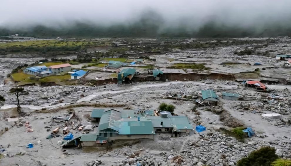
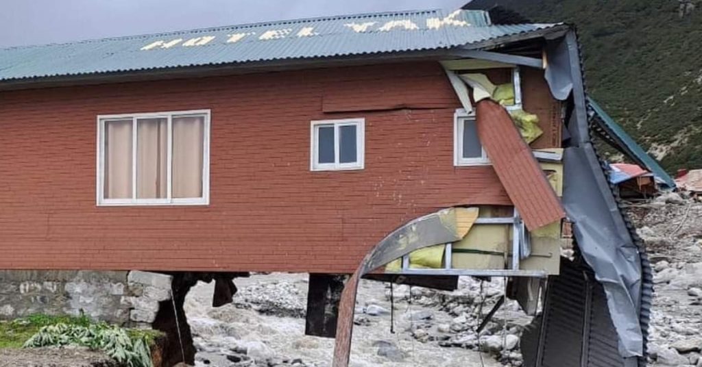
On August 16, 2024, a devastating flood caused by a glacial lake outburst from the Para Chhumo Glacial Lake turned this beautiful and historic village into a disaster zone. The flood occurred about 10 kilometers upstream of Thame village, along the Thame River.
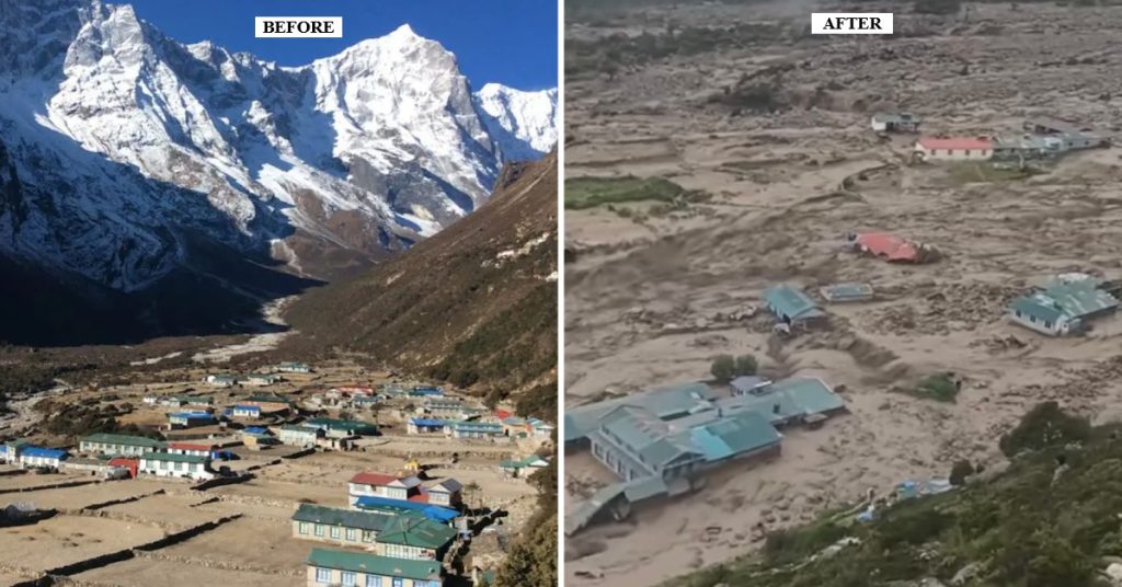
Thame Village had 55 homes, including a school, and a health post. The glacial lake outburst flood (GLOF) destroyed 25 homes and damaged many others. The Khumbu Pasang Lhamu Rural Municipality reported losses of about USD 10 million, including damages to a 930-kilowatt micro-hydro project, a bridge, and a road.
Climate Change Effects
The impact of climate change is more severe in the high Himalayan region than in other parts of Nepal. According to the Department of Hydrology and Meteorology, the average temperature in Nepal’s Himalayan region rises by 0.08 degrees Celsius per year, causing ice and snow to melt and new glacial lakes to form.
According to a report by ICIMOD and UNDP, In 2000, there were 3,601 glacial lakes in Nepal’s three major river basins—Koshi, Gandaki, and Karnali—covering an area of 179.56 square kilometers. As glaciers melt, the number and size of these lakes are increasing. By 2005, the number had risen to 3,696 lakes covering 186.44 square kilometers. In 2015, there were 3,624 lakes occupying 195.39 square kilometers. Between 2000 and 2015, 23 glaciers expanded by 15.8 square kilometers. Since 2015, no new studies have been conducted, but the number and size of these glaciers have likely continued to increase.
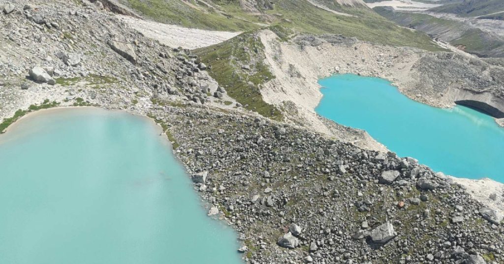
Experts believe the Thame disaster is related to climate change. Dr. Mohan Bahadur Chand, a glaciologist at Kathmandu University, states that the lower lake was formed around 1990, and a smaller upper lake appeared only in 2010. “The ongoing disaster can be linked to climate change,” says Dr. Chand.
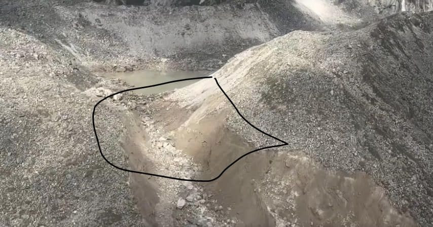
Experts say that the main reason for flooding in Thame is climate change. Researchers and scientists studying the climate and temperature of the Himalayan region. Based on the analysis of the pictures taken from the satellite reported that the upper lake exploded due to the pressure of the avalanche and came to another lake.
While analyzing the satellite images, Amrit Thapa, researching the Himalayan region of Nepal and studying at the University of Alaska, says that an avalanche appears in the upper lake. He says that when the upper lake burst, the water started flowing into the lower lake, but it did not burst like a balloon.
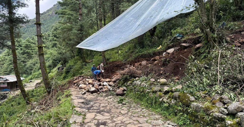
Local Efforts to Recovery
The local government and people of the world-famous Mount Everest region are addressing climate-induced devastating disasters themselves.
The local government and community have set an example with their quick response to the disaster. Mingma Chhiri Sherpa, chairman of the rural municipality, said that the municipality has been actively working in the affected areas since the flood. The rural municipality initially provided relief of $371 per family, while the federal government only gave $111 per family.
The rural municipality allocated about $528,213.66 for the affected residents. Of this, $109,430 is planned for rebuilding homes, $44,637 for damaged small hydropower projects, $297,585 for repairing bridges and roads, and $37,198 for studying the Himalayan region within the municipality.
Lakpa Sherpa, an advisor to the Khumbu Pasang Lhamu Rural Municipality, said that the local government took action because the federal government was slow in providing relief and reconstruction support.”We have informed the Prime Minister about the situation here, but it seems the work will not be completed even in one year,” he said. “Tourism is the main source of income for Solukhumbu, so reconstruction must happen quickly.”
Sherpa also mentioned that locals from Solukhumbu living abroad are raising funds for Thame’s reconstruction. They have raised an estimated $500,000 to 700,000. Kami Rita Sherpa, who holds a record for climbing Mount Everest, is also raising funds through ‘Go Fund Me’. He plans to distribute the collected money through the rural municipality’s one-door system.
Quick Restoration of Electricity
Due to local efforts, the Thamekhola small hydropower project, which was completely damaged by floods, was restored in just 18 days. Built-in 1999 with support from Australia, the project initially produced 650 kilowatts of electricity, which was later expanded to 930 kilowatts with funding from the Indian Embassy.
Mingma Chiri Sherpa stated that the Khumbu Electricity Company and the rural municipality made temporary repairs, restoring 27 kilowatts of electricity to 18 villages, including Namche and Khumjung. The Indian government has promised USD 74,962 for further repairs.
The rural municipality has also taken steps to reopen a local school. Tents needed for temporary schooling were transported to the village by mule. The basic school structure was destroyed in the flood, so 50 students were relocated to Khumjung Secondary School with residential facilities.
Lakpa Sherpa of Khumbu Pasang Lhamu Rural Municipality said, “The response of the local people and government to this climate disaster can serve as a model for other countries.
Mukesh Pokhrel is a Kathmandu-based journalist and EJN Fellow